Data Service
생활속의 위성항법, 보다 안전하게 제공하겠습니다!


Overview of the Services
NTRIP(Network Transport of RTCM via Internet Protocol)
- The conventional differential global navigation satellite system (DGNSS) uses medium-wave media to send global navigation satellite system (GNSS) position error correction signals. In contrast, NTRIP uses the Internet network to send GNSS correction signals.
- RTCM(Radio Technical Committee for Maritime Service)
- GNSS correction signal transmission data format
- RTCM(Radio Technical Committee for Maritime Service)
- It is an applied protocol that uses the Internet to transmit real-time GNSS data.
- NTRIP is capable of wireless access through the mobile IP network based on hypertext transfer protocol (HTTP).
- NTRIP Server
- It transmits NTRIP source data to the NTRIP Caster through the HTTP server.
- NTRIP Caster
- It can distribute data to around 1,000 users simultaneously.
- NTRIP Client
- It transmits DGNSS data using a terminal with Internet access.
- It is capable of using a floating IP network as it uses the Internet (TCP/IP).
How to Use NTRIP Client
- How to start:
- 1Download and install NTRIP Client Download NTRIP Client
- 2Access NMPNT's NTRIP Caster through NTRIP Client
- NMPNT's NTRIP Client
- Select the purpose of use, then access
- Other general purpose (NTRIP Client)
- Host/Port : ntrip.nDGNSS.go.kr / 2101
- ID/PW : nmpnt / nmpnt
- NMPNT's NTRIP Client
- 3Select Mountpoint and receive data
- MountPoint: Observatory name_Data format (e.g., OKCH_RTCM23: Okcheon Monitoring Station’s RTCM2.3)
NTRIP Service Blueprint

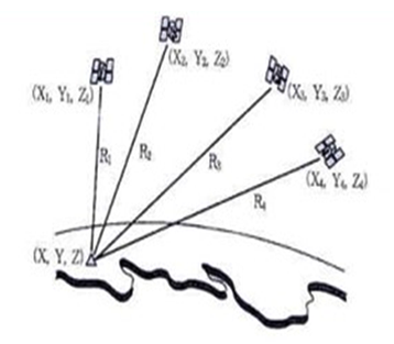
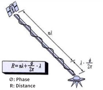
Positioning Method
| Method | DGPS | RTK |
|---|---|---|
| Principle |
|
|
| Observes the distance through the time observation of the code as radio signals travel from the satellite to the receiver. | Observes the distance by using the phase of a carrier wave existing from the satellite to the receiver. |
RTCM Message by Version
| Category | Version Region |
RTCM2.3(RTK) | RTCM3.0(RTK) | RTCM3.2(RTK) | Receiver | Remarks |
|---|---|---|---|---|---|---|
| Inland Reference Stations | Chungju |  |
|
|
NetR9 | |
| Seongju | |
|
|
NetR9 | ||
| Yeongju | |
|
|
NetR9 | ||
| Pyeongchang | |
|
|
NetR9 | ||
| Muju | |
|
|
NetR9 | ||
| Chuncheon | |
|
|
NetR9 | ||
| Maritime Reference Station | Eocheongdo | |
|
|
NetR9 | |
| Palmido | |
|
|
NetR9 | ||
| Socheongdo | |
|
|
NetR9 | ||
| Gageodo | |
|
|
NetR9 | ||
| Geomundo | |
|
|
NetR9 | ||
| Marado | |
|
|
NetR9 | ||
| Yeongdo | |
|
|
NetR9 | ||
| Homigot | |
|
|
NetR9 | ||
| Ulleungdo | |
|
|
NetR9 | ||
| Jumunjin | |
|
|
NetR9 | ||
| Jeojin | |
|
|
NetR9 | ||
| Inland Integrity Monitoring Station | Samcheok (Pyeongyang) | |
|
|
NetR9 | |
| Donneomisan (Chungju, Yeongju) |
|
|
|
NetR9,8 | ||
| Hongcheon (Chuncheon) | |
|
|
NetR9 | ||
| Mungyeong (Seongju) | |
|
|
NetR9 | ||
| Daejeon (Muju) | |
|
|
Alloy | ||
| Maritime Integrity Monitoring Station | Dokdo | |
|
|
NetR9 | |
| Anheung | |
|
|
NetR9 | ||
| Maldo | |
|
|
NetR9 | ||
| Hongdo | |
|
|
NetR9 | ||
| Dangsado | |
|
|
NetR9 | ||
| Sorido | |
|
|
NetR9 | ||
| Seoimal | |
|
|
NetR9 | ||
| Gasado | |
|
|
NetR9 | ||
| Jukbyeon | |
|
|
NetR9 | ||
| Sokcho | |
|
|
NetR9 | ||
| Total (Place/Operating/To be added) |
34 / 34 / 0 | 34 / 34 / 0 | ||||
| 68 / 68 / 0 | ||||||
