Services
생활속의 위성항법, 보다 안전하게 제공하겠습니다!


About eLoran
Concept & Features
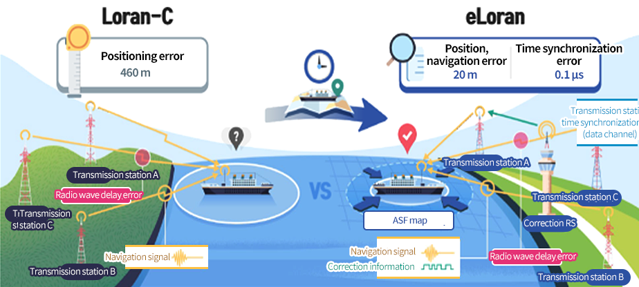
The enhanced LOng RAnge Navigation (eLoran) is a cutting-edge terrestrial navigation system that measures the time radio waves travel from at least three transmission stations on the ground to calculate positioning and provide precise time and frequency information. eLoran transmits low frequency (100 kHz) eLoran pulses to provide positioning, navigation, and timing (PNT) information. It has also improved positioning accuracy to less than 20 m through data transmission (Loran data channel; LDC) and error correction map (ASF map).
Establishment & Current Status
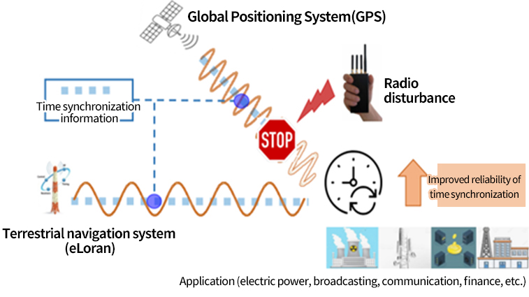
Positioning, navigation, and timing (PNT) information is basic information that is widely used across the social and economic domains. It is also a core infrastructure resource of South Korea. However, the signals are received from satellites about 20,000 km away. As a result, the signal strength is very weak. This makes it vulnerable to radio interference or jamming. Accordingly, the government promoted the development of eLoran technology (2016–2020) in order to improve limitations of the global navigation satellite system (GNSS) and establish a supplementary national PNT system. As a result, eLoran, resistant to radio interference, was built. The eLoran system consists of the Integrated Operation and Control Station (IOCS), Pohang/Gwangju/Incheon eLoran/Loran-C Stations (to be relocated to Socheongdo), and Incheon/Pyeongtaek Correction Reference Stations.
eLoran Time Synchronization System
Although there was no Loran-C signal time synchronization function, integrated eLoran/Loran-C time synchronization devices were installed in Pohang and Gwangju eLoran/Loran-C Stations and eLoran Stations to prepare for situations wherein GNSS time signals cannot be received. It is possible to use time synchronization services with signals from only one station. Through each system, the time difference between GNSS and eLoran/Loran-C is analyzed and precise UTC time information (≤1 μs) is also provided.
Areas of Application
Positioning and navigation : Provide safe navigation information on maritime fields and moving objects such as vessels.
Time synchronization : Major national ICT infrastructures and private sector (finance, broadcasting, information and communication, etc.).
