Glossary
생활속의 위성항법, 보다 안전하게 제공하겠습니다!


Overview of GALILEO
Overview of GALILEO
Galileo is a global navigation satellite system (GNSS) jointly developed by the European Union (EU) and European Space Agency (ESA).
GNSS Project of Europe
Europe's GNSS is divided into GNSS-1 and GNSS-2. GNSS-1 enables DGPS positioning of several meters over a wide area by considering the entire visible area of a geostationary satellite as the service area and transmits GPS and GLONASS correction data to aircraft and ships in operation; while GNSS-2 is a unique global positioning system (GPS).
| Name | Purpose | Target | Started in | |
|---|---|---|---|---|
| GNSS-1 | EGNOS | Send correction information of the existing GPS and GLONASS | Europe | 1998 |
| GNSS-2 | GALILEO | A unique GPS for civilian use | Worldwide | 2008 |
- Currently, Europe is developing a system called European Geostationary Navigation Overlay System (EGNOS), which is similar to the Wide Area Augmentation System (WAAS). This is another name for GNSS-1, the first stage of the European community's plan to develop the next-generation GPS called global navigation satellite system (GNSS). Europe recognized the need to develop a new civilian-only satellite navigation system that can replace GPS and GLONASS. Accordingly, they launched the GNSS Project in response to satellite navigation systems that are being developed by the USA and Russia.
GNSS-1
The GNSS-1 is composed of the three following systems.
GBAS
- Independent local satellite correction system
SBAS
- A correction system that transmits correction data of GPS and GLONASS. Europe is developing EGNOS as a wide-range correction system. Parts on the ground are scattered around the entire area where EGNOS services are provided in order to measure and correct GPS signals. They are also all connected to the master control station.France Telecom's Earth Station in Aussa-guel and Deutsche Telekom in Raisting will serve as primary base stations. From the AOR-E satellite, IOR satellite in the Indian Ocean, and H2A rocket from Japan, ARTEMIS, which was scheduled to be launched into the geostationary orbit at longitude 21.4° east in 2000, is expected to transmit the correction information of GPS and GLONASS. After the Galileo system is completed, EGNOS will be used as a subsidiary of Galileo.
GNSS-2
Galileo is the first civilian satellite navigation system and an independent global satellite navigation system. The existing satellite navigation systems, GPS and GLONASS, were developed for military purposes, and were limited for civilian use and commercial purposes. Galileo is a satellite navigation system developed by the EU in order to break away from the influence of satellite navigation systems led by the USA and Russia.
Galileo is independent from other systems but can interpret information with GPS and GLONASS. It measures Galileo terrestrial reference frame (GTRF) by taking the international terrestrial reference frame (ITRF) into account, and measures time in UTC. Navigation information and messages provide other navigation data messages such as weather warnings, traffic information, and accident warning lights. Moreover, integrity information will be provided independently of navigation information.
Development of Galileo
| Period | Purpose |
|---|---|
| Initial (Oct. 1999 –Dec. 2000) | Designed the Galileo System (equipment, power generation model, etc.) |
| Development (Jan. 2001 –Dec. 2001) | Verified the satellite design |
| Test (Jan. 2002 –Dec. 2004) | Manufactured and launched three MEO satellites, verified H/W of some development equipment of the ground station and satellite |
| Advancement (Jan. 2005 –Dec. 2007) | Determined the orbit, manufactured and launched the correction satellite, completed the ground station, allocated the satellite, and test-operated the system |
| Supply (2008–present) | Initiated supply to European countries |
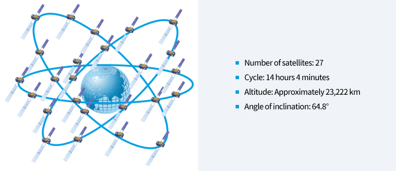
Status of the Galileo Satellite
| Total satellites in constellation | 30 SC |
|---|---|
| operational | 27 SC |
| Spares | 3 SC |
